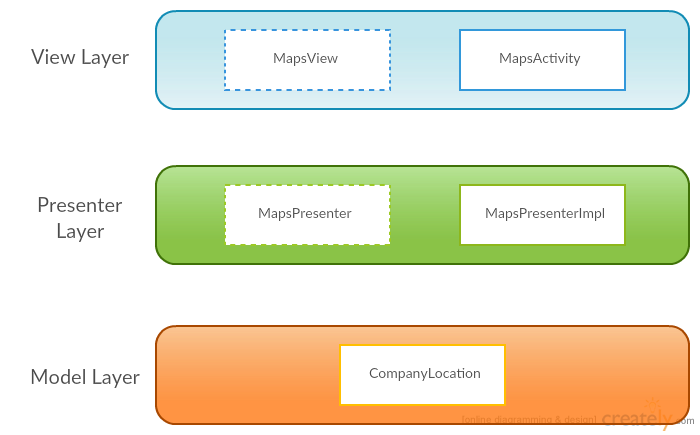
In the previous post, we talked about the idea behind geo-fencing, why is it so useful and what is the reason behind choosing a particular design pattern like MVP. It was most like an introductory step before getting our hands dirty with some actual source code. Thus, in this part of the series, I will try to go through the different layers of the MVP pattern and will try to explain as much as possible the things that are happening there.
The GeofenceExample application
As said earlier, the application which will be used as an example will rely on the usage of predefined geo-fences with some radius. The main task is to display these geo-fences on a map and fire events each time we enter or exit the predefined radius of such a location. Lets see the main classes separated by layers based on the MVP design pattern:

Model Layer
This is the most simple layer of all of them. It consists of a single class called CompanyLocation. This is a simple POJO which contains a LatLng and Geofence fields. It represents a single company which has particular GPS coordinates and contains a geofence in it. That’s all!
View Layer
The View layer consists of MapsActivity and MapsView (interface). In other words, the single activity we have will be our actual view. It’s responsibilities will be only to show / hide information and controls from the screen and to initialize the entities from the Presenter layer.
The MapsView is a simple interface which describes the major actions which the MapsActivity is responsible for.
Presenter Layer
The number of the entities in the Presenter Layer is no different than the number in the View Layer. Again we have just two items in here - a simple interface and a class which implements it. Now, the MapsPresenterImpl class, which implements MapsPresenter, is a bit more complicated. That’s due to the fact that this class is playing the role of a hub. It contains instances of all of the components in the application and is distributing responsibilities and tasks to the right places.
The MapsPresenterImpl class also contains a function for ‘fetching’ data from e remote server. But in order to keep the example as simple as possible, the actual communication with a server is replaced by manually creating some dummy CompanyLocation objects and including them in a List.
Despite acting like a hub, the MapsPresenterImpl class is also listening for several important events to occur. Such events are:
- A change in the user’s location - when a new location is registered, the pointer of the user’s current location on the MapView must be updated.
public void onLocationChanged(Location location)
- A successfully established connection to the Google Location Service
public void onLocationApiManagerConnected()
- A successful result from the Google Geofencing API
public void onGeofenceResultAvailable()
Feel free to share, comment & give your opinion on the topic!
